
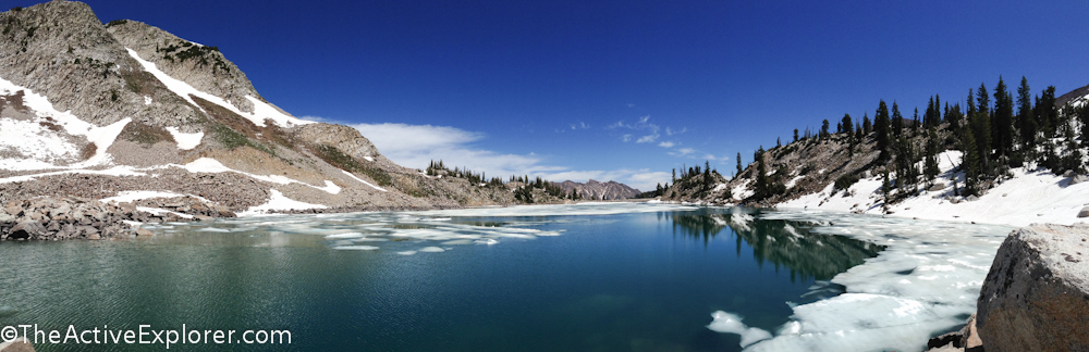
White Pine Lake delivered one of the best views of the hiking season thus far!
The spring snow-melt means more hikers on the trails and I find myself journeying higher and higher to find barely thawed trails with more quiet. Pondering my topo map, I spotted White Pine Lake sitting at nearly 10,000 feet of elevation, one of the highest in the Wasatch Mountains. Feeling confident that at least a small part would be covered in lingering snow, I grabbed my pack and headed for the door.
Undoubtedly, I made the right choice. The hike ranks as one of my favorites so far this season. The lower section were offered pretty canyon views and numerous small streams from snow melt, perfect for testing a pair of Powerdrain shoes Columbia Sportswear sent me to try. The upper section was still covered in snow, changing the look of the landscape entirely. The perfect shoes for streams were not perfect for snow, and I’m certain a few hikers had fun watching me slide.
Sitting under the face of White Baldy, the lake itself was stunning and peaceful with the last bits of its white icy cover providing a dramatic contract to the blue sky reflected in the water. Other than myself, only one other couple opted to make the slide down the snowy-sloped bowl to the shoreline, and that was as I was leaving. I found the peace I was seeking.
White Pine Lake and the slightly lower Red Pine Lake are both accessed from the same trailhead in Little Cottonwood Canyon just outside of Salt Lake City. The trail to White Pine Lake follows an old jeep road, but it’s been long enough that it’s not very apparent. Because it was a road, the grade is relatively gradual, however the tradeoff is a longer hike.
The White Pine Trailhead is located on Little Cottonwood Canyon Road at a paved parking area with vault-style toilets. Like most parking in the area, it fills fast leaving the overflow to park along the road.
From the parking area, the routes to both lakes follow the same trail for about a mile. The trail to White Pine Lake takes off to the left and uphill, while the route to Red Pine Lake crosses the stream to the right. So, if you cross the stream, you’re going the wrong way.
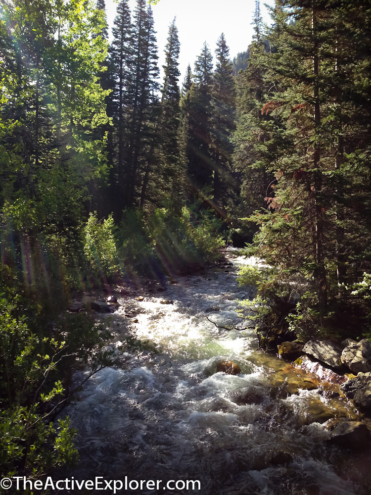
The river near the White Pine Trailhead.
Winding first uphill then through sweeping meadows, the changing terrain keeps things interesting and isn’t overly exhausting. I lost count of the small streams crossing the trail and at times running on top of it for a ways. My strategy was to walk right through the water in the Powerdrain shoes worn with quality synthetic socks. I became the envy of other hikers who had to pick their way along trying to keep their feet dry. I’ll post a full review of the shoes in a separate post.
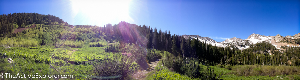
Meadows along the White Pine Trail
Nearing the lake, the trail reaches a large boulder field (covered in snow during my hike) and traverses west along the ridge between Red Baldy and White Baldy. It was here that I discovered the limitations of my shoes, slipping and falling repeatedly. They were clearly water shoes, not designed for traction in snow. Luckily, my standard response is to laugh off such embarrassing moments.
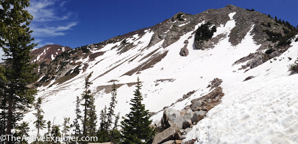
Looking back on the snow-packed trail to White Pine Lake.
On the far side of the traverse, a bowl cradling White Pine Lake opened up before me. I stood at the rim contemplating how I could make it down the steep, snowy slope to the water’s edge without falling again. After a few false starts, I accepted that I would fall and opted for a controlled-slide strategy. It worked so well I stayed upright.
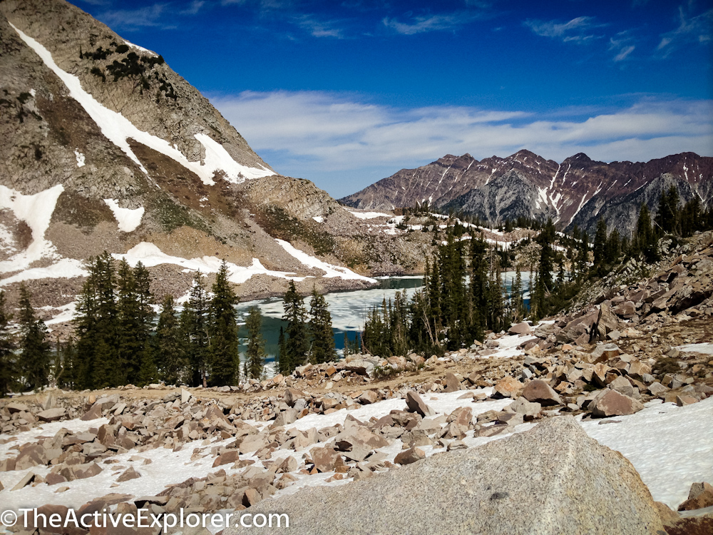
White pine Lake from the ridge.
Picking my way across a snow-covered pile of boulders, occasionally punching a hole through with my foot, I finally made it to the water, finding a large warm rock to perch on for lunch. Slipping off my shoes, I relished the solitude of being the only hiker at the lake. The sun warmed my chilled toes and life was good. It wasn’t until after I had enjoyed my lunch and snapped all of my photos that another couple ventured down, and even then, they were out of eyesight.
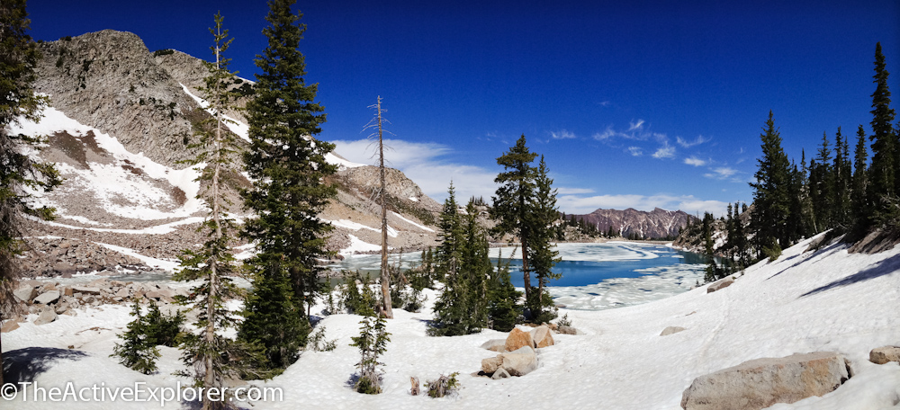
The snowy approach to my lunch spot.
I considered venturing off trail and hiking across the ridge that separates White Pine Lake from Red Pine Like. While there is no established route, I had seen several reports that it was very feasible and thus would create a loop hike. Remembering my stumbles in the snow, I thought better of it, especially since I was hiking solo.
Hiking out the way I came, I had more laughable moments on the traverse and steep decent off of the slope.
Some people don’t like out-and-back trails, but I’ve always found that the view looks different in each direction, especially in the mountains. Such was that case on the White Pine Trail. I felt as though I were exiting on a completely different route. So pretty.
If you go:
Trailhead – From the Y at 209 (9000 South) joins Little Cottonwood Canyon Road, head up canyon 5.5 miles. The trailhead is on the right and includes an off-road paved lot with vault bathrooms.
Gear – This trail may require snow crossings until mid-summer so trekking poles and good boots are recommended. Much of the trail is exposed, so stay hydrated and pack plenty of water in the summer. Also pack your 10 Essentials and a lunch to enjoy by the lake. If you have a quality camera, this is a trail where you may want to carry the extra weight.
Difficulty – The grade up to the lake is gentle, with 2,350 feet of elevation gain over 4.5 miles. However, it reaches 10,120 feet at its highest point, so you may feel the altitude if you’re not acclimated. Additionally, 9-mile [round-trip] hike can be more challenging when there is snow cover to negotiate.
Comments 9
It is tough to find an all purpose outdoor footwear. I have so many outdoor shoes, my closet almost resembles a females (although my shoes are all piled in a heap). Problem is you need to change shoes for every new condition.
I’ve found it a challenge to choose one pair of shoes for the day here during spring/early summer. Just this weekend I went from dirt, to mud, to water, to snow. And confession… mine are in a pile too, except for the stilettos, they get their own shelf.
Hi I just found your blog through a link from Outside Magazine. It’s so strange to me hearing that people are voluntarily moving from the East Coast to SLC. That was rare a few years ago. Many locals had a complex about not being as cool as Seattle, as diverse as San Francisco, or as crazy as Las Vegas. Salt Lake was like a petulant 16-year-old, always trying to prove our worth, while the popular kids dismissed, sneered and snickered.
But the area has changed a lot in the last decade. I did the opposite and left the mountains to go to a 24-hour city and after nearly a decade in the Rotten Apple and other areas back East, I’m happy to be back to the Wasatch.
Love the pics of White Pine. I was up there about a month ago and got turned around about 200 vertical feet below the pass, down to the lake. The snow was waist high in spots and I didn’t have daylight on my side to continue trudging for another 45 minutes. Your pics have inspired me to go back soon. Welcome to SLC.
Hi Jake! Thank you for the warm welcome!
I keep hearing similar stories from people here who either came and never left, or left and returned. I’m thrilled with my new home town. After spending three weeks here learning to ski, I returned to Florida and knew I had to move.
I had a tough time on the slope that I think turned you around and it wasn’t deep, just slick, when I was there. Some people did turn around. Of course that was my strategy to have a peaceful lunch:)
Erika
Glad you made it there! Cool place indeed. Go up the pfeifferhorn next!!
Pfeifferhorn is on my short list to do soon!
Pingback: Hiking Alta: A ridgeline picnic above Cecret Lake
This one looks like a bucket list must.
Brian-
It’s a great hike! I just hiked to Red Pine (same trailhead) last weekend and it was very nice too! White has more meadows.